Geolocate

Capas topographic map

Click on the map to display elevation.

About this map

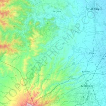
Name: Capas topographic map, elevation, terrain.

Location: Capas, Tarlac, Central Luzon, 2315, Philippines (15.24507 120.24593 15.42602 120.61788)

Average elevation: 853 ft

Minimum elevation: 108 ft

Maximum elevation: 4,751 ft

Other topographic maps

Click on a map to view its topography, its elevation and its terrain.

Kamatis

Philippines > Tarlac > Capas

Average elevation: 253 ft

Gear up for your next adventure:

🛡️Bear Spray Outdoor - Protection in bear country hikes
🗺️Topographic Maps - Detailed topo maps for hiking, exploring and outdoor navigation
🧭Orienteering Set - Complete compass and map reading kit
🧭Map Reading Tools - Tools and kits for map navigation
🪶Compact Camp Shovel - Folding shovel for campsite tasks

As an Amazon Associate, this site earns from qualifying purchases at no extra cost to you.