Geolocate
👉 Easily get elevation data in JSON, GeoTIFF and KML formats using Elevation API
Thank you for supporting this site ❤️
Make a donation

Kamatis topographic map

Click on the map to display elevation.

About this map

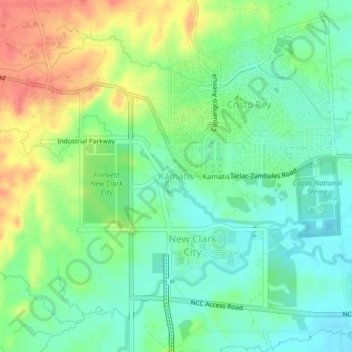
Name: Kamatis topographic map, elevation, terrain.

Location: Kamatis, Capas, Tarlac, Central Luzon, 2315, Philippines (15.33274 120.50842 15.37274 120.54842)

Average elevation: 253 ft

Minimum elevation: 174 ft

Maximum elevation: 377 ft

Other topographic maps

Click on a map to view its topography, its elevation and its terrain.

Capas

Philippines > Tarlac > Capas

Average elevation: 853 ft

Gear up for your next adventure:

🎒Outdoor Daypacks - Lightweight backpacks designed for carrying maps and essential gear
🌄Hiking Binoculars - Compact binoculars for scenic views and trail spotting
🦶Hiking Gaiters - Keep debris and water out of your boots
🧭Compass with Lanyard - Easy‑carry compass for navigation
🔌Solar Panel Charger - Charge gear sustainably outdoors

As an Amazon Associate, this site earns from qualifying purchases at no extra cost to you.