
Make a donation
Gear up for your next adventure:
As an Amazon Associate, this site earns from qualifying purchases at no extra cost to you.
Mega topographic map
Click on the map to display elevation.
Make a donation
Gear up for your next adventure:
As an Amazon Associate, this site earns from qualifying purchases at no extra cost to you.
Mega
Mega is a town in southern Ethiopia. Located between Moyale and Yabelo on the paved highway south to Kenya, in the Borena Zone of the Oromia, this town has a latitude and longitude of 4°01′N 38°15′E / 4.017°N 38.250°E / 4.017; 38.250 with an elevation of 1740 meters above sea level. Named for a nearby mountain, this town is the administrative center of Dire woreda.
Make a donation
Gear up for your next adventure:
As an Amazon Associate, this site earns from qualifying purchases at no extra cost to you.
About this map
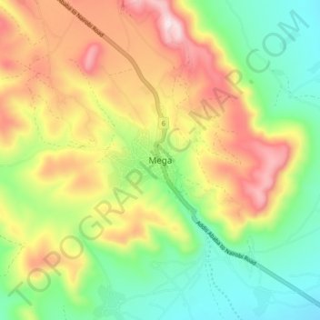
Name: Mega topographic map, elevation, terrain.
Location: Mega, Borena, Oromia Region, Ethiopia (4.01880 38.28089 4.09880 38.36089)
Average elevation: 5,728 ft
Minimum elevation: 4,875 ft
Maximum elevation: 6,883 ft
Make a donation
Gear up for your next adventure:
As an Amazon Associate, this site earns from qualifying purchases at no extra cost to you.