Geolocate

Tulsa topographic map

Click on the map to display elevation.

About this map

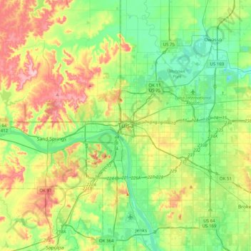
Name: Tulsa topographic map, elevation, terrain.

Location: Tulsa, Tulsa County, Oklahoma, 74172, United States (35.99568 -96.15291 36.31568 -95.83291)

Average elevation: 722 ft

Minimum elevation: 545 ft

Maximum elevation: 1,056 ft

Tulsa County trails, hiking, mountain biking, running and outdoor activities

Other topographic maps

Click on a map to view its topography, its elevation and its terrain.

Audobon Park

United States > Oklahoma > Tulsa County > Tulsa

Average elevation: 705 ft

Wellington South

United States > Oklahoma > Tulsa County > Tulsa

Average elevation: 676 ft

Terrace Park

United States > Oklahoma > Tulsa County > Tulsa

Average elevation: 735 ft

Gear up for your next adventure:

🧭GPS Watch Accessories - Bands and chargers for GPS watches
📡Handheld GPS Device - Reliable handheld GPS for outdoor navigation
🔪Outdoor Multitools - Essential survival tools for gear repair and field use
🧦Hiking Socks - Comfortable socks to prevent blisters on long hikes
📶Vehicle Signal Boosters - Improve reception in rural areas while driving to trailheads

As an Amazon Associate, this site earns from qualifying purchases at no extra cost to you.