
Make a donation
Gear up for your next adventure:
As an Amazon Associate, this site earns from qualifying purchases at no extra cost to you.
Walldorf topographic map
Click on the map to display elevation.
Make a donation
Gear up for your next adventure:
As an Amazon Associate, this site earns from qualifying purchases at no extra cost to you.
About this map
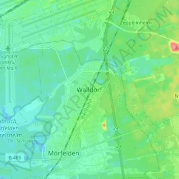
Name: Walldorf topographic map, elevation, terrain.
Average elevation: 348 ft
Minimum elevation: 295 ft
Maximum elevation: 538 ft
Make a donation
Gear up for your next adventure:
As an Amazon Associate, this site earns from qualifying purchases at no extra cost to you.
Other topographic maps
Click on a map to view its topography, its elevation and its terrain.
Mönchbruch von Mörfelden und Rüsselsheim
Deutschland > Hessen > Kreis Groß-Gerau > Walldorf
Anfang 2001 wurde nördlich des Jagdschlosses am Rande der Mönchbruchwiesen eine überdachte Aussichtsplattform in 4,10 Meter Höhe errichtet, die sich sehr gut für Tierbeobachtungen eignet.
Average elevation: 315 ft