
Butztown topographic map
Click on the map to display elevation.
About this map
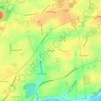
Name: Butztown topographic map, elevation, terrain.
Average elevation: 361 ft
Minimum elevation: 200 ft
Maximum elevation: 505 ft
Northampton County trails, hiking, mountain biking, running and outdoor activities
Other topographic maps
Click on a map to view its topography, its elevation and its terrain.
Middletown
United States > Pennsylvania > Northampton County > Bethlehem Township > Butztown
Average elevation: 338 ft
Green Pond
United States > Pennsylvania > Northampton County > Bethlehem Township
Average elevation: 407 ft