
Make a donation
Gear up for your next adventure:
As an Amazon Associate, this site earns from qualifying purchases at no extra cost to you.
Sheffield topographic map
Click on the map to display elevation.
Make a donation
Gear up for your next adventure:
As an Amazon Associate, this site earns from qualifying purchases at no extra cost to you.
Sheffield
The highest point in Sheffield is an unnamed summit in the northeast corner of town, with an elevation of 2,543 feet (775 m) above sea level, between Granby Mountain and Norris Mountain.[5]
Make a donation
Gear up for your next adventure:
As an Amazon Associate, this site earns from qualifying purchases at no extra cost to you.
About this map
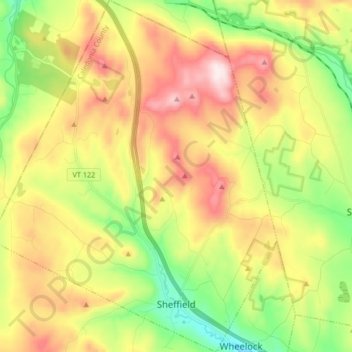
Name: Sheffield topographic map, elevation, terrain.
Location: Sheffield, Caledonia County, Vermont, 05866, United States (44.58579 -72.20249 44.70450 -72.06638)
Average elevation: 1,545 ft
Minimum elevation: 751 ft
Maximum elevation: 2,523 ft
Caledonia County trails, hiking, mountain biking, running and outdoor activities
Make a donation
Gear up for your next adventure:
As an Amazon Associate, this site earns from qualifying purchases at no extra cost to you.
Other topographic maps
Click on a map to view its topography, its elevation and its terrain.
Make a donation
Gear up for your next adventure:
As an Amazon Associate, this site earns from qualifying purchases at no extra cost to you.
Make a donation
Gear up for your next adventure:
As an Amazon Associate, this site earns from qualifying purchases at no extra cost to you.