Geolocate

Aschheim topographic map

Click on the map to display elevation.

About this map

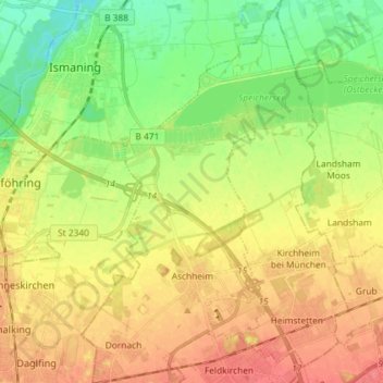
Name: Aschheim topographic map, elevation, terrain.

Location: Aschheim, Landkreis München, Bavaria, 85609, Germany (48.14429 11.67393 48.24110 11.75571)

Average elevation: 1,654 ft

Minimum elevation: 1,558 ft

Maximum elevation: 1,745 ft

Other topographic maps

Click on a map to view its topography, its elevation and its terrain.

Martinsried

Germany > Bavaria > Landkreis München > Planegg

Average elevation: 1,801 ft

Hofolding

Germany > Bavaria > Landkreis München

Average elevation: 1,998 ft

Holzhausen

Germany > Bavaria > Landkreis München

Average elevation: 2,175 ft

Eglfing

Germany > Bavaria > Landkreis München > Haar

Average elevation: 1,772 ft

Deisenhofen

Germany > Bavaria > Landkreis München > Oberhaching

Average elevation: 1,942 ft

Westerham

Germany > Bavaria > Landkreis München > Taufkirchen > Westerham

Average elevation: 1,854 ft

Gear up for your next adventure:

🛡️Bear Spray Outdoor - Protection in bear country hikes
🕶️Glacier Sunglasses - Side shields to protect eyes from high-altitude snow glare
🚗GPS Dash Cams - Record your scenic drives through mountain passes and canyons
🪶Multi‑Purpose Knife - Useful blade for camp and trail
🪶Compact Camp Shovel - Folding shovel for campsite tasks

As an Amazon Associate, this site earns from qualifying purchases at no extra cost to you.