
Make a donation
Gear up for your next adventure:
As an Amazon Associate, this site earns from qualifying purchases at no extra cost to you.
La Cumbre topographic map
Click on the map to display elevation.
Make a donation
Gear up for your next adventure:
As an Amazon Associate, this site earns from qualifying purchases at no extra cost to you.
La Cumbre
La Cumbre, que anteriormente se llamaba San Jerónimo, debe su nombre al ferrocarril, ya que fue la villa más alta del ramal, a una altitud de 1141 m s. n. m. por cuya razón se le dio el nombre “La Cumbre” cuando se abrió el primer horario de verano, el 1 de diciembre de 1900.
Make a donation
Gear up for your next adventure:
As an Amazon Associate, this site earns from qualifying purchases at no extra cost to you.
About this map
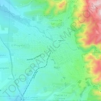
Name: La Cumbre topographic map, elevation, terrain.
Average elevation: 3,845 ft
Minimum elevation: 3,576 ft
Maximum elevation: 4,596 ft
Make a donation
Gear up for your next adventure:
As an Amazon Associate, this site earns from qualifying purchases at no extra cost to you.
Other topographic maps
Click on a map to view its topography, its elevation and its terrain.
Faldas del Uritorco
Argentina > Córdoba > Pedanía Dolores > Capilla del Monte
Average elevation: 3,474 ft
Make a donation
Gear up for your next adventure:
As an Amazon Associate, this site earns from qualifying purchases at no extra cost to you.
Make a donation
Gear up for your next adventure:
As an Amazon Associate, this site earns from qualifying purchases at no extra cost to you.