
Thank you for supporting this site ❤️
Make a donation
Make a donation
Gear up for your next adventure:
As an Amazon Associate, this site earns from qualifying purchases at no extra cost to you.
A Rúa topographic map
Click on the map to display elevation.
Thank you for supporting this site ❤️
Make a donation
Make a donation
Gear up for your next adventure:
As an Amazon Associate, this site earns from qualifying purchases at no extra cost to you.
About this map
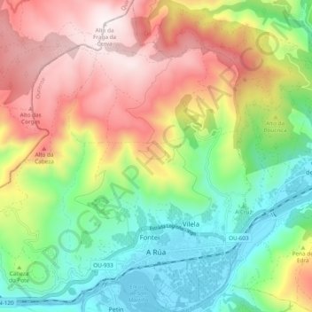
Name: A Rúa topographic map, elevation, terrain.
Location: A Rúa, Valdeorras, Ourense, Galicia, 32350, Spain (42.38173 -7.16772 42.45184 -7.08461)
Average elevation: 2,277 ft
Minimum elevation: 942 ft
Maximum elevation: 4,058 ft
Thank you for supporting this site ❤️
Make a donation
Make a donation
Gear up for your next adventure:
As an Amazon Associate, this site earns from qualifying purchases at no extra cost to you.
Other topographic maps
Click on a map to view its topography, its elevation and its terrain.
Carballeda
Spain > Galicia > Valdeorras > Carballeda de Valdeorras > Carballeda
Average elevation: 2,411 ft