
Thank you for supporting this site ❤️
Make a donation
Make a donation
Gear up for your next adventure:
As an Amazon Associate, this site earns from qualifying purchases at no extra cost to you.
Huajuapan topographic map
Click on the map to display elevation.
Thank you for supporting this site ❤️
Make a donation
Make a donation
Gear up for your next adventure:
As an Amazon Associate, this site earns from qualifying purchases at no extra cost to you.
About this map
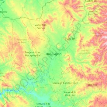
Name: Huajuapan topographic map, elevation, terrain.
Location: Huajuapan, Huajuapan de León, Oaxaca, 69000, Mexico (17.64885 -97.93806 17.96885 -97.61806)
Average elevation: 6,056 ft
Minimum elevation: 4,491 ft
Maximum elevation: 8,661 ft
Thank you for supporting this site ❤️
Make a donation
Make a donation
Gear up for your next adventure:
As an Amazon Associate, this site earns from qualifying purchases at no extra cost to you.