
Make a donation
Gear up for your next adventure:
As an Amazon Associate, this site earns from qualifying purchases at no extra cost to you.
Matinloc Shrine topographic map
Click on the map to display elevation.
Make a donation
Gear up for your next adventure:
As an Amazon Associate, this site earns from qualifying purchases at no extra cost to you.
About this map
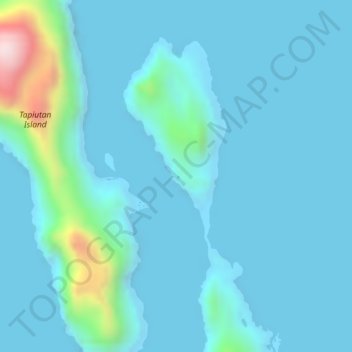
Name: Matinloc Shrine topographic map, elevation, terrain.
Location: Matinloc Shrine, Palawan, Mimaropa, Philippines (11.20296 119.27513 11.20306 119.27523)
Average elevation: 161 ft
Minimum elevation: -36 ft
Maximum elevation: 1,355 ft
Make a donation
Gear up for your next adventure:
As an Amazon Associate, this site earns from qualifying purchases at no extra cost to you.
Other topographic maps
Click on a map to view its topography, its elevation and its terrain.
Busuanga
Elevation The municipality's western and central portions are predominantly rough and mountainous with rolling to hilly terrain. A part of this is the Chinabayan Mountain and Wayan Range that still support extensive parches of Molave forest and Cogon grassland (features which are dominant in the locale).…
Average elevation: 52 ft
Make a donation
Gear up for your next adventure:
As an Amazon Associate, this site earns from qualifying purchases at no extra cost to you.
Cagayancillo
There are neither mountain ranges nor forested areas in the municipality. A hilly portion in the north-eastern part of the main island has a slope of 3-82%. The other areas are flat with the highest elevation around 2 to 3 meters. The majority of the island has a sandy loam soil not enough to support a forest.
Average elevation: 0 ft
Make a donation
Gear up for your next adventure:
As an Amazon Associate, this site earns from qualifying purchases at no extra cost to you.
Make a donation
Gear up for your next adventure:
As an Amazon Associate, this site earns from qualifying purchases at no extra cost to you.
Make a donation
Gear up for your next adventure:
As an Amazon Associate, this site earns from qualifying purchases at no extra cost to you.
Cuyo
Cuyo Island is the largest island of the Cuyo Archipelago, about 13 kilometers (8.1 mi) long, 7.5 kilometers (4.7 mi) wide, and with an area of 57 square kilometers (22 sq mi). Mount Bonbon with an elevation of 817 feet (249 m) is the highest mountain in Cuyo island. The Island is under the jurisdiction of the…
Average elevation: 0 ft
Make a donation
Gear up for your next adventure:
As an Amazon Associate, this site earns from qualifying purchases at no extra cost to you.
Make a donation
Gear up for your next adventure:
As an Amazon Associate, this site earns from qualifying purchases at no extra cost to you.
Make a donation
Gear up for your next adventure:
As an Amazon Associate, this site earns from qualifying purchases at no extra cost to you.
Make a donation
Gear up for your next adventure:
As an Amazon Associate, this site earns from qualifying purchases at no extra cost to you.
Make a donation
Gear up for your next adventure:
As an Amazon Associate, this site earns from qualifying purchases at no extra cost to you.
Likas Island
Philippines > Palawan > Kalayaan
West York Island, also known as Likas Island (Filipino: Pulo ng Likas, lit. 'Island of Naturality'; Mandarin Chinese: 西月島/西月岛; pinyin: Xīyuè Dǎo; Vietnamese: đảo Bến Lạc), and several other names. With an area of 18.6 hectares (46 acres), it is the third largest of the naturally…
Average elevation: 0 ft
Make a donation
Gear up for your next adventure:
As an Amazon Associate, this site earns from qualifying purchases at no extra cost to you.
Make a donation
Gear up for your next adventure:
As an Amazon Associate, this site earns from qualifying purchases at no extra cost to you.
Make a donation
Gear up for your next adventure:
As an Amazon Associate, this site earns from qualifying purchases at no extra cost to you.
Make a donation
Gear up for your next adventure:
As an Amazon Associate, this site earns from qualifying purchases at no extra cost to you.
Make a donation
Gear up for your next adventure:
As an Amazon Associate, this site earns from qualifying purchases at no extra cost to you.
Busuanga
Elevation The municipality's western and central portions are predominantly rough and mountainous with rolling to hilly terrain. A part of this is the Chinabayan Mountain and Wayan Range that still support extensive parches of Molave forest and Cogon grassland (features which are dominant in the locale).…
Average elevation: 52 ft
Make a donation
Gear up for your next adventure:
As an Amazon Associate, this site earns from qualifying purchases at no extra cost to you.
Make a donation
Gear up for your next adventure:
As an Amazon Associate, this site earns from qualifying purchases at no extra cost to you.
Make a donation
Gear up for your next adventure:
As an Amazon Associate, this site earns from qualifying purchases at no extra cost to you.
Busuanga
Elevation The municipality's western and central portions are predominantly rough and mountainous with rolling to hilly terrain. A part of this is the Chinabayan Mountain and Wayan Range that still support extensive parches of Molave forest and Cogon grassland (features which are dominant in the locale).…
Average elevation: 52 ft
Make a donation
Gear up for your next adventure:
As an Amazon Associate, this site earns from qualifying purchases at no extra cost to you.
Kalayaan
The islets that comprise the municipality are generally flat. The highest ground elevation is approximately 2 metres (6 ft 7 in) above sea level.
Average elevation: 0 ft
Make a donation
Gear up for your next adventure:
As an Amazon Associate, this site earns from qualifying purchases at no extra cost to you.
Make a donation
Gear up for your next adventure:
As an Amazon Associate, this site earns from qualifying purchases at no extra cost to you.
Make a donation
Gear up for your next adventure:
As an Amazon Associate, this site earns from qualifying purchases at no extra cost to you.
Cuyo
Cuyo Island is the largest island of the Cuyo Archipelago, about 13 kilometres (8.1 mi) long, 7.5 kilometres (4.7 mi) wide, and with an area of 57 square kilometres (22 sq mi). Mount Bonbon with an elevation of 817 ft (249 m) is the highest mountain in Cuyo island. The Island is under the jurisdiction of the…
Average elevation: 0 ft
Make a donation
Gear up for your next adventure:
As an Amazon Associate, this site earns from qualifying purchases at no extra cost to you.