
Thank you for supporting this site ❤️
Make a donation
Make a donation
Gear up for your next adventure:
As an Amazon Associate, this site earns from qualifying purchases at no extra cost to you.
Gemeinde Spitz topographic map
Click on the map to display elevation.
Thank you for supporting this site ❤️
Make a donation
Make a donation
Gear up for your next adventure:
As an Amazon Associate, this site earns from qualifying purchases at no extra cost to you.
About this map
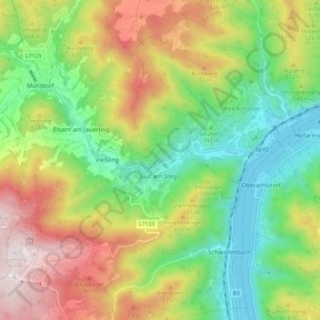
Name: Gemeinde Spitz topographic map, elevation, terrain.
Location: Gemeinde Spitz, Bezirk Krems, Lower Austria, 3620, Austria (48.32607 15.33806 48.39088 15.42745)
Average elevation: 1,663 ft
Minimum elevation: 646 ft
Maximum elevation: 3,156 ft
Thank you for supporting this site ❤️
Make a donation
Make a donation
Gear up for your next adventure:
As an Amazon Associate, this site earns from qualifying purchases at no extra cost to you.