
Thank you for supporting this site ❤️
Make a donation
Make a donation
Gear up for your next adventure:
As an Amazon Associate, this site earns from qualifying purchases at no extra cost to you.
Superior topographic map
Click on the map to display elevation.
Thank you for supporting this site ❤️
Make a donation
Make a donation
Gear up for your next adventure:
As an Amazon Associate, this site earns from qualifying purchases at no extra cost to you.
About this map
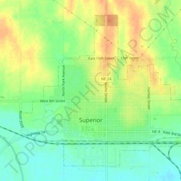
Name: Superior topographic map, elevation, terrain.
Location: Superior, Nuckolls County, Nebraska, 68978, United States (40.01296 -98.08548 40.03856 -98.04561)
Average elevation: 1,608 ft
Minimum elevation: 1,545 ft
Maximum elevation: 1,677 ft
Nebraska trails, hiking, mountain biking, running and outdoor activities
Thank you for supporting this site ❤️
Make a donation
Make a donation
Gear up for your next adventure:
As an Amazon Associate, this site earns from qualifying purchases at no extra cost to you.