Geolocate

Ruston topographic map

Click on the map to display elevation.

About this map

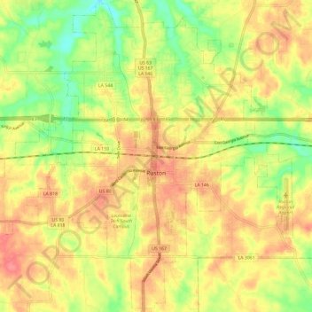
Name: Ruston topographic map, elevation, terrain.

Location: Ruston, Lincoln Parish, Louisiana, United States (32.48010 -92.68676 32.57714 -92.56913)

Average elevation: 269 ft

Minimum elevation: 138 ft

Maximum elevation: 367 ft

Lincoln Parish trails, hiking, mountain biking, running and outdoor activities

Other topographic maps

Click on a map to view its topography, its elevation and its terrain.

Hilly

United States > Louisiana > Lincoln Parish

Average elevation: 213 ft

Barnet Springs

United States > Louisiana > Lincoln Parish > Ruston

Average elevation: 295 ft

Gear up for your next adventure:

📻Weather Alert Radios - Stay informed of storm risks while off-the-grid
🔭Telescopic Hiking Pole - Adjustable pole for hiking stability
🧭Compass with Lanyard - Easy‑carry compass for navigation
Backpacking Tents - Weight-optimized shelters for multi-day topographic surveys
📚Navigation Handbooks - Master the art of reading topographic maps and using a compass

As an Amazon Associate, this site earns from qualifying purchases at no extra cost to you.