
Make a donation
Gear up for your next adventure:
As an Amazon Associate, this site earns from qualifying purchases at no extra cost to you.
Aarsele topographic map
Click on the map to display elevation.
Make a donation
Gear up for your next adventure:
As an Amazon Associate, this site earns from qualifying purchases at no extra cost to you.
Aarsele
Aarsele ligt in Zandlemig Vlaanderen op het Plateau van Tielt. De hoogte varieert van 12 tot 39 meter, waarbij de dorpskom op ruim 30 meter hoogte ligt op een cuestarug die hier begint en doorloopt tot Koolskamp. Hierdoor ligt Aarsele op een waterscheiding. De Speibeek voert het water naar het zuiden af, via de Oude Mandelbeek. De Reigerbeek voert het water naar het noordoosten af, via de Poekebeek.
Make a donation
Gear up for your next adventure:
As an Amazon Associate, this site earns from qualifying purchases at no extra cost to you.
About this map
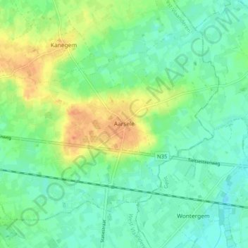
Name: Aarsele topographic map, elevation, terrain.
Location: Aarsele, Tielt, West-Vlaanderen, België (50.97783 3.37302 51.01646 3.45256)
Average elevation: 56 ft
Minimum elevation: 13 ft
Maximum elevation: 125 ft
Make a donation
Gear up for your next adventure:
As an Amazon Associate, this site earns from qualifying purchases at no extra cost to you.
Other topographic maps
Click on a map to view its topography, its elevation and its terrain.