
Make a donation
Gear up for your next adventure:
As an Amazon Associate, this site earns from qualifying purchases at no extra cost to you.
Cartaya topographic map
Click on the map to display elevation.
Make a donation
Gear up for your next adventure:
As an Amazon Associate, this site earns from qualifying purchases at no extra cost to you.
Cartaya
El término municipal tiene una extensión de 226,4 km²[4] con una altitud media de 26 msnm.[4]
Make a donation
Gear up for your next adventure:
As an Amazon Associate, this site earns from qualifying purchases at no extra cost to you.
About this map
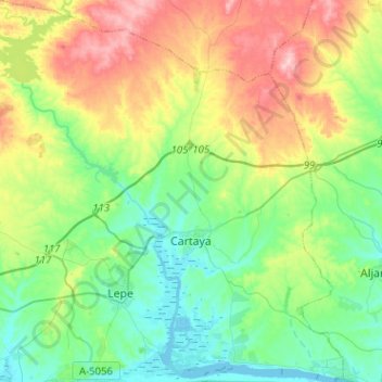
Name: Cartaya topographic map, elevation, terrain.
Location: Cartaya, Costa Occidental, Huelva, Andalucía, España (37.20819 -7.30201 37.41052 -7.05308)
Average elevation: 197 ft
Minimum elevation: 0 ft
Maximum elevation: 594 ft
Make a donation
Gear up for your next adventure:
As an Amazon Associate, this site earns from qualifying purchases at no extra cost to you.
Other topographic maps
Click on a map to view its topography, its elevation and its terrain.
Make a donation
Gear up for your next adventure:
As an Amazon Associate, this site earns from qualifying purchases at no extra cost to you.
Make a donation
Gear up for your next adventure:
As an Amazon Associate, this site earns from qualifying purchases at no extra cost to you.
Villa Antonia
España > Andalucía > Costa Occidental > Ayamonte > Pozo del Camino
Average elevation: 85 ft
Playa del Hoyo
España > Andalucía > Costa Occidental > Isla Cristina > Playa del Hoyo
Average elevation: 7 ft