Geolocate

Humphreys topographic map

Click on the map to display elevation.

About this map

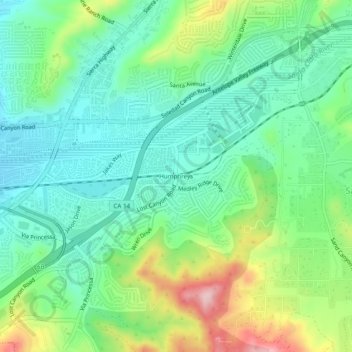
Name: Humphreys topographic map, elevation, terrain.

Location: Humphreys, Santa Clarita, Los Angeles County, California, 91387, United States (34.39027 -118.46064 34.43027 -118.42064)

Average elevation: 1,627 ft

Minimum elevation: 1,391 ft

Maximum elevation: 2,156 ft

Los Angeles County trails, hiking, mountain biking, running and outdoor activities

Other topographic maps

Click on a map to view its topography, its elevation and its terrain.

Basin

United States > California > Los Angeles County > Santa Clarita

Average elevation: 1,490 ft

Gear up for your next adventure:

🪶Paracord Bracelet - Survival bracelet with built‑in tools
🎒Waterproof Dry Bags - Keep your electronics and maps dry inside your pack
🖼️Topo Map Wall Art - Decorative topographic prints of famous peaks and regions
🛰️Satellite Messengers - Emergency SOS and two-way messaging for off-grid adventures
🔭Telescopic Hiking Pole - Adjustable pole for hiking stability

As an Amazon Associate, this site earns from qualifying purchases at no extra cost to you.