
Chalet-à-Gobet topographic map
Interactive map
Click on the map to display elevation.
About this map
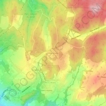
Name: Chalet-à-Gobet topographic map, elevation, terrain.
Average elevation: 2,779 ft
Minimum elevation: 2,405 ft
Maximum elevation: 3,087 ft
Other topographic maps
Click on a map to view its topography, its elevation and its terrain.
Chalet à Mathey
Switzerland > Vaud > District de Lausanne > Lausanne > Montblesson
Chalet à Mathey, Vers-chez-les-Blanc, Montblesson, Lausanne, District de Lausanne, Vaud, 1000, Switzerland
Average elevation: 2,651 ft