
Centro Habana topographic map
Interactive map
Click on the map to display elevation.
About this map
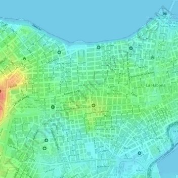
Name: Centro Habana topographic map, elevation, terrain.
Location: Centro Habana, Havana, San Miguel del Padrón, Cuba (23.12344 -82.37859 23.14597 -82.35834)
Average elevation: 43 ft
Minimum elevation: -3 ft
Maximum elevation: 148 ft
Other topographic maps
Click on a map to view its topography, its elevation and its terrain.
Guanabacoa
Cuba > San Miguel del Padrón > Havana
Guanabacoa, Havana, San Miguel del Padrón, Cuba
Average elevation: 144 ft
San Miguel del Padrón
Cuba > San Miguel del Padrón > Havana
San Miguel del Padrón, Havana, San Miguel del Padrón, Cuba
Average elevation: 171 ft