
San Miguel del Padrón topographic map
Interactive map
Click on the map to display elevation.
About this map
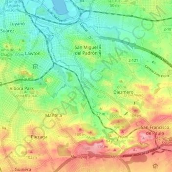
Name: San Miguel del Padrón topographic map, elevation, terrain.
Location: San Miguel del Padrón, Havana, San Miguel del Padrón, Cuba (23.05250 -82.35143 23.11192 -82.27206)
Average elevation: 171 ft
Minimum elevation: 0 ft
Maximum elevation: 407 ft
Other topographic maps
Click on a map to view its topography, its elevation and its terrain.
Guanabacoa
Cuba > San Miguel del Padrón > Havana
Guanabacoa, Havana, San Miguel del Padrón, Cuba
Average elevation: 144 ft
Centro Habana
Cuba > San Miguel del Padrón > Havana
Centro Habana, Havana, San Miguel del Padrón, Cuba
Average elevation: 43 ft