
Make a donation
Gear up for your next adventure:
As an Amazon Associate, this site earns from qualifying purchases at no extra cost to you.
Lichtel topographic map
Click on the map to display elevation.
Make a donation
Gear up for your next adventure:
As an Amazon Associate, this site earns from qualifying purchases at no extra cost to you.
About this map
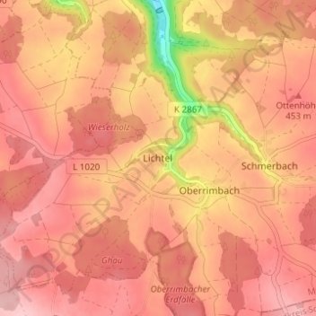
Name: Lichtel topographic map, elevation, terrain.
Average elevation: 1,444 ft
Minimum elevation: 1,099 ft
Maximum elevation: 1,568 ft
Make a donation
Gear up for your next adventure:
As an Amazon Associate, this site earns from qualifying purchases at no extra cost to you.
Other topographic maps
Click on a map to view its topography, its elevation and its terrain.
Blumweiler
Deutschland > Baden-Württemberg > Main-Tauber-Kreis > Creglingen
Average elevation: 1,450 ft
Oberrimbach
Deutschland > Baden-Württemberg > Main-Tauber-Kreis > Creglingen
Average elevation: 1,463 ft
Reinsbronn
Deutschland > Baden-Württemberg > Main-Tauber-Kreis > Creglingen
Average elevation: 1,086 ft
Waldmannshofen
Deutschland > Baden-Württemberg > Main-Tauber-Kreis > Creglingen
Average elevation: 1,086 ft
Make a donation
Gear up for your next adventure:
As an Amazon Associate, this site earns from qualifying purchases at no extra cost to you.