
Make a donation
Gear up for your next adventure:
As an Amazon Associate, this site earns from qualifying purchases at no extra cost to you.
Sarsan topographic map
Click on the map to display elevation.
Make a donation
Gear up for your next adventure:
As an Amazon Associate, this site earns from qualifying purchases at no extra cost to you.
About this map
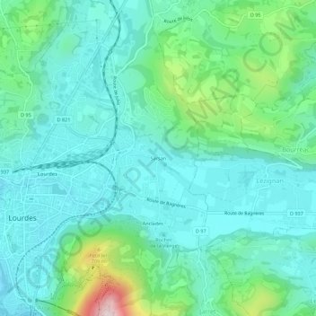
Name: Sarsan topographic map, elevation, terrain.
Average elevation: 1,575 ft
Minimum elevation: 1,230 ft
Maximum elevation: 2,874 ft
Make a donation
Gear up for your next adventure:
As an Amazon Associate, this site earns from qualifying purchases at no extra cost to you.
Other topographic maps
Click on a map to view its topography, its elevation and its terrain.
Lac de Lourdes
France > Occitanie > Hautes-Pyrénées > Lourdes
Le lac de Lourdes est un lac des Pyrénées françaises d'une superficie de 52 ha pour une altitude de 422 m. Il se situe sur la commune de Lourdes dans le département des Hautes-Pyrénées en région Occitanie.
Average elevation: 1,460 ft