
Make a donation
Gear up for your next adventure:
As an Amazon Associate, this site earns from qualifying purchases at no extra cost to you.
Le Pommeret topographic map
Click on the map to display elevation.
Make a donation
Gear up for your next adventure:
As an Amazon Associate, this site earns from qualifying purchases at no extra cost to you.
About this map
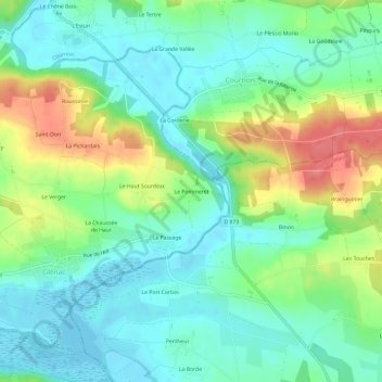
Name: Le Pommeret topographic map, elevation, terrain.
Average elevation: 85 ft
Minimum elevation: -7 ft
Maximum elevation: 259 ft
Make a donation
Gear up for your next adventure:
As an Amazon Associate, this site earns from qualifying purchases at no extra cost to you.
Other topographic maps
Click on a map to view its topography, its elevation and its terrain.
La Gacilly
France > Bretagne > Morbihan > La Gacilly
La superficie de la commune est de 1 648 hectares ; son altitude varie de 4 à 98 mètres.
Average elevation: 135 ft
Glénac
France > Bretagne > Morbihan > La Gacilly
La superficie de l’ancienne commune est de 1 370 hectares (13,7 km2) ; son altitude varie entre 2 et 87 m.
Average elevation: 102 ft
La Chapelle-Gaceline
France > Bretagne > Morbihan > La Gacilly
La superficie de la commune est de 779 hectares ; son altitude varie de 5 à 52 mètres.
Average elevation: 82 ft
La Gacilly
France > Bretagne > Morbihan > La Gacilly
La superficie de la commune est de 1 648 hectares ; son altitude varie de 4 à 98 mètres.
Average elevation: 135 ft
Make a donation
Gear up for your next adventure:
As an Amazon Associate, this site earns from qualifying purchases at no extra cost to you.