
Victoria topographic map
Click on the map to display elevation.
About this map
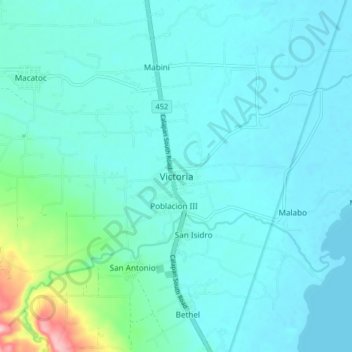
Name: Victoria topographic map, elevation, terrain.
Location: Victoria, Oriental Mindoro, Mimaropa, 5205, Philippines (13.13338 121.23877 13.21338 121.31877)
Average elevation: 92 ft
Minimum elevation: 7 ft
Maximum elevation: 630 ft
Other topographic maps
Click on a map to view its topography, its elevation and its terrain.
Calapan
Philippines > Oriental Mindoro
The overall land characteristic is a wide plain with rivers, interspersed with wetlands at the seacoast periphery. The highest elevation is 187 m (614 ft) above sea level at Bulusan Hill, a 6-kilometre (3.7 mi) long landform east of the city, which interrupts the mostly flat terrain north-east of the…
Average elevation: 39 ft
Naujan Lake
Philippines > Oriental Mindoro > Malabo
Mount Naujan, elevation 1,380 feet (420 m) and one of the inactive volcanoes of the country, is situated northeast of the geographic center of the lake. Several thermal springs and solfataras are reported to exist on the eastern border of the Naujan Lake.
Average elevation: 151 ft
Calapan
Philippines > Oriental Mindoro
The overall land characteristic is a wide plain with rivers, interspersed with wetlands at the seacoast periphery. The highest elevation is 187 m (614 ft) above sea level at Bulusan Hill, a 6-kilometre (3.7 mi) long landform east of the city, which interrupts the mostly flat terrain north-east of the…
Average elevation: 39 ft