
Make a donation
Gear up for your next adventure:
As an Amazon Associate, this site earns from qualifying purchases at no extra cost to you.
Freixial topographic map
Click on the map to display elevation.
Make a donation
Gear up for your next adventure:
As an Amazon Associate, this site earns from qualifying purchases at no extra cost to you.
About this map
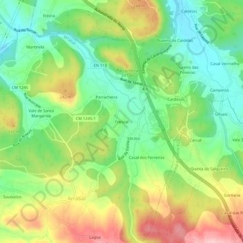
Name: Freixial topographic map, elevation, terrain.
Location: Freixial, Arrabal, Leiria, 2420-020, Portugal (39.69237 -8.73837 39.73237 -8.69837)
Average elevation: 597 ft
Minimum elevation: 344 ft
Maximum elevation: 958 ft
Make a donation
Gear up for your next adventure:
As an Amazon Associate, this site earns from qualifying purchases at no extra cost to you.
Other topographic maps
Click on a map to view its topography, its elevation and its terrain.
Make a donation
Gear up for your next adventure:
As an Amazon Associate, this site earns from qualifying purchases at no extra cost to you.
Make a donation
Gear up for your next adventure:
As an Amazon Associate, this site earns from qualifying purchases at no extra cost to you.
Make a donation
Gear up for your next adventure:
As an Amazon Associate, this site earns from qualifying purchases at no extra cost to you.
Bidoeira de Cima
A Bidoeira de Cima foi um lugar pertencente à freguesia de Colmeias. Com a elevação de Milagres a freguesia, em 1750, passou a integrar-se nesta. Fruto do progresso económico registado desde os meados do século passado, a situação da Bidoeira de Cima tendeu para a autonomia. Deste percurso histórico,…
Average elevation: 472 ft
Make a donation
Gear up for your next adventure:
As an Amazon Associate, this site earns from qualifying purchases at no extra cost to you.
Make a donation
Gear up for your next adventure:
As an Amazon Associate, this site earns from qualifying purchases at no extra cost to you.