
Make a donation
Gear up for your next adventure:
As an Amazon Associate, this site earns from qualifying purchases at no extra cost to you.
Morungava topographic map
Click on the map to display elevation.
Make a donation
Gear up for your next adventure:
As an Amazon Associate, this site earns from qualifying purchases at no extra cost to you.
About this map
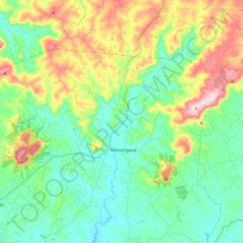
Name: Morungava topographic map, elevation, terrain.
Average elevation: 407 ft
Minimum elevation: 36 ft
Maximum elevation: 1,230 ft
Make a donation
Gear up for your next adventure:
As an Amazon Associate, this site earns from qualifying purchases at no extra cost to you.
Other topographic maps
Click on a map to view its topography, its elevation and its terrain.
Sítio do Beto
Brasil > Rio Grande do Sul > Região Metropolitana de Porto Alegre > Gravataí
Average elevation: 446 ft
Lago do Parcão
Brasil > Rio Grande do Sul > Região Metropolitana de Porto Alegre > Gravataí
Average elevation: 128 ft
Morro da Palha
Brasil > Rio Grande do Sul > Região Metropolitana de Porto Alegre > Gravataí
Average elevation: 709 ft
Cerro Morungava
Brasil > Rio Grande do Sul > Região Metropolitana de Porto Alegre > Gravataí
Average elevation: 190 ft
Make a donation
Gear up for your next adventure:
As an Amazon Associate, this site earns from qualifying purchases at no extra cost to you.
Santa Tecla
Brasil > Rio Grande do Sul > Região Metropolitana de Porto Alegre > Gravataí > Santa Tecla
Average elevation: 377 ft
Itacolomi
Brasil > Rio Grande do Sul > Região Metropolitana de Porto Alegre > Gravataí
Average elevation: 217 ft
Cascatinha Mato Fino - Morungava
Brasil > Rio Grande do Sul > Região Metropolitana de Porto Alegre > Gravataí
Average elevation: 427 ft
Morro das Cabras (Carta Topográfica do Exército)
Brasil > Rio Grande do Sul > Região Metropolitana de Porto Alegre > Gravataí
Average elevation: 440 ft
Make a donation
Gear up for your next adventure:
As an Amazon Associate, this site earns from qualifying purchases at no extra cost to you.
Mata do Café
Brasil > Rio Grande do Sul > Região Metropolitana de Porto Alegre > Gravataí
Average elevation: 167 ft