
Thank you for supporting this site ❤️
Make a donation
Make a donation
Gear up for your next adventure:
As an Amazon Associate, this site earns from qualifying purchases at no extra cost to you.
Te Awamutu topographic map
Click on the map to display elevation.
Thank you for supporting this site ❤️
Make a donation
Make a donation
Gear up for your next adventure:
As an Amazon Associate, this site earns from qualifying purchases at no extra cost to you.
About this map
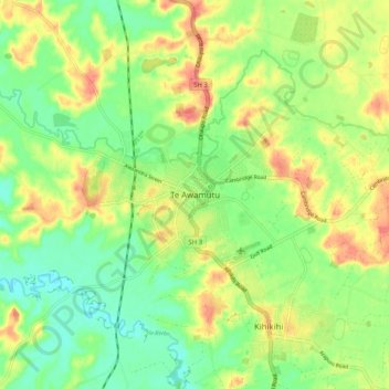
Name: Te Awamutu topographic map, elevation, terrain.
Location: Te Awamutu, Waipā District, Waikato, 3840, New Zealand (-38.05016 175.28578 -37.97016 175.36578)
Average elevation: 187 ft
Minimum elevation: 82 ft
Maximum elevation: 325 ft
Thank you for supporting this site ❤️
Make a donation
Make a donation
Gear up for your next adventure:
As an Amazon Associate, this site earns from qualifying purchases at no extra cost to you.
Other topographic maps
Click on a map to view its topography, its elevation and its terrain.
Rangiaowhia War Memorial Domain
New Zealand > Waikato > Waipa District > Kihikihi > Rangiaowhia
Average elevation: 226 ft