Geolocate

Huntly topographic map

Click on the map to display elevation.

About this map

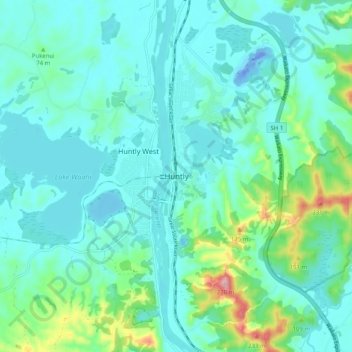
Name: Huntly topographic map, elevation, terrain.

Location: Huntly, Waikato District, Waikato, 3700, New Zealand (-37.59840 175.11883 -37.51840 175.19883)

Average elevation: 135 ft

Minimum elevation: -118 ft

Maximum elevation: 794 ft

Other topographic maps

Click on a map to view its topography, its elevation and its terrain.

Lake E

New Zealand > Waikato > Waikato District

Average elevation: 128 ft

Lake Kimihia

New Zealand > Waikato > Waikato District

Average elevation: 112 ft

Gear up for your next adventure:

🧼Biodegradable Camping Soap - Eco‑friendly soap for outdoor hygiene
🛰️Satellite Messengers - Emergency SOS and two-way messaging for off-grid adventures
🧤Hiking Gloves - Protective gloves for rugged trails
Solar GPS Watches - Advanced multisport watches with built-in topographic maps
💧Water Purification System - Clean water on the trail with reliable purifiers

As an Amazon Associate, this site earns from qualifying purchases at no extra cost to you.