
Vila Real topographic map
Interactive map
Click on the map to display elevation.
About this map
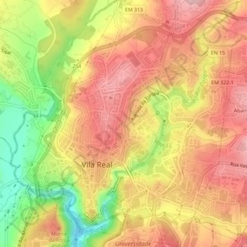
Name: Vila Real topographic map, elevation, terrain.
Location: Vila Real, Douro, Nord, Portugal (41.28752 -7.75996 41.31812 -7.72060)
Average elevation: 1,345 ft
Minimum elevation: 1,007 ft
Maximum elevation: 1,614 ft
Other topographic maps
Click on a map to view its topography, its elevation and its terrain.