
Make a donation
Gear up for your next adventure:
As an Amazon Associate, this site earns from qualifying purchases at no extra cost to you.
Panama City Beach topographic map
Click on the map to display elevation.
Make a donation
Gear up for your next adventure:
As an Amazon Associate, this site earns from qualifying purchases at no extra cost to you.
Panama City Beach
Panama City Beach, located in Bay County, Florida, features a predominantly flat topography typical of coastal areas. Its terrain is characterized by low elevations, generally ranging between 20 to 30 feet (6 to 9 meters) above sea level. This flatness is interrupted by occasional sand dunes that rise up along the shore, contributing to the region’s scenic beachfront. The city lies along the Gulf of Mexico, with the Gulf Lagoon and St. Andrews Bay nearby, creating a unique environment of sandy stretches and shallow waters. The area’s terrain is ideal for beach activities and is shaped by both natural processes and human development. The land is part of the larger Gulf Coastal Plain, offering expansive views and easy access to water from almost any point in the region.
Make a donation
Gear up for your next adventure:
As an Amazon Associate, this site earns from qualifying purchases at no extra cost to you.
About this map
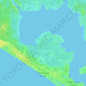
Name: Panama City Beach topographic map, elevation, terrain.
Location: Panama City Beach, Bay County, Florida, United States (30.16509 -85.95800 30.29679 -85.78590)
Average elevation: 7 ft
Minimum elevation: -7 ft
Maximum elevation: 56 ft
Bay County trails, hiking, mountain biking, running and outdoor activities
Make a donation
Gear up for your next adventure:
As an Amazon Associate, this site earns from qualifying purchases at no extra cost to you.
Other topographic maps
Click on a map to view its topography, its elevation and its terrain.
Make a donation
Gear up for your next adventure:
As an Amazon Associate, this site earns from qualifying purchases at no extra cost to you.
Make a donation
Gear up for your next adventure:
As an Amazon Associate, this site earns from qualifying purchases at no extra cost to you.
Make a donation
Gear up for your next adventure:
As an Amazon Associate, this site earns from qualifying purchases at no extra cost to you.