
Make a donation
Gear up for your next adventure:
As an Amazon Associate, this site earns from qualifying purchases at no extra cost to you.
Limerlé topographic map
Click on the map to display elevation.
Make a donation
Gear up for your next adventure:
As an Amazon Associate, this site earns from qualifying purchases at no extra cost to you.
About this map
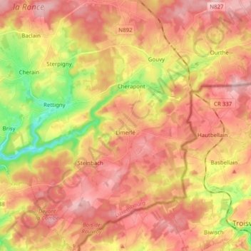
Name: Limerlé topographic map, elevation, terrain.
Location: Limerlé, Gouvy, Bastogne, Luxembourg, Wallonie, Belgique (50.11023 5.85790 50.20880 5.97285)
Average elevation: 1,545 ft
Minimum elevation: 1,211 ft
Maximum elevation: 1,765 ft
Make a donation
Gear up for your next adventure:
As an Amazon Associate, this site earns from qualifying purchases at no extra cost to you.
Other topographic maps
Click on a map to view its topography, its elevation and its terrain.
Baraque de Fraiture
Belgique > Luxembourg > Bastogne > Vielsalm
Au milieu du XIX siècle, les routes nationales Vielsalm-La Roche et Houffalize-Manhay nouvellement créées se croisent en un endroit isolé, considéré comme le quatrième plus haut point de Belgique (651 mètres d'altitude). Un habitant du village de Fraiture, voisin de ce lieu « désert », désire…
Average elevation: 2,001 ft
Make a donation
Gear up for your next adventure:
As an Amazon Associate, this site earns from qualifying purchases at no extra cost to you.
Make a donation
Gear up for your next adventure:
As an Amazon Associate, this site earns from qualifying purchases at no extra cost to you.
Make a donation
Gear up for your next adventure:
As an Amazon Associate, this site earns from qualifying purchases at no extra cost to you.
Make a donation
Gear up for your next adventure:
As an Amazon Associate, this site earns from qualifying purchases at no extra cost to you.
Make a donation
Gear up for your next adventure:
As an Amazon Associate, this site earns from qualifying purchases at no extra cost to you.
Make a donation
Gear up for your next adventure:
As an Amazon Associate, this site earns from qualifying purchases at no extra cost to you.
Make a donation
Gear up for your next adventure:
As an Amazon Associate, this site earns from qualifying purchases at no extra cost to you.
Make a donation
Gear up for your next adventure:
As an Amazon Associate, this site earns from qualifying purchases at no extra cost to you.
Chenogne
Belgique > Luxembourg > Bastogne
Chenogne est implantée dans un petit vallon où l'altitude varie entre 480 et 500 m.
Average elevation: 1,634 ft
Make a donation
Gear up for your next adventure:
As an Amazon Associate, this site earns from qualifying purchases at no extra cost to you.
Make a donation
Gear up for your next adventure:
As an Amazon Associate, this site earns from qualifying purchases at no extra cost to you.
Make a donation
Gear up for your next adventure:
As an Amazon Associate, this site earns from qualifying purchases at no extra cost to you.
Assenois
Belgique > Luxembourg > Bastogne
(Le lieu-dit Le Sart est sur Assenois L'Église et pas Assenois Vaux-sur-sûre) En 1985, des fouilles mettent au jour seize tombes, réparties sous six tumulus, au lieu-dit Le Sart, à une altitude comprise entre 390 et 405 m. Chaque tumulus contient au moins une tombe. Seul le tumulus V, avec trois tombes, ne…
Average elevation: 1,677 ft
Make a donation
Gear up for your next adventure:
As an Amazon Associate, this site earns from qualifying purchases at no extra cost to you.
Remichampagne
Belgique > Luxembourg > Bastogne
Remichampagne est un petit village ardennais situé à 500 m à l'est de l’autoroute A26/E25 et à 10 km au sud-ouest de Bastogne. L'altitude y avoisine les 450 m. Plusieurs anciennes fermes en pierre du pays (schiste) dont certaines sont toujours en activité jalonnent les rues de cette localité assez…
Average elevation: 1,565 ft
Make a donation
Gear up for your next adventure:
As an Amazon Associate, this site earns from qualifying purchases at no extra cost to you.
Make a donation
Gear up for your next adventure:
As an Amazon Associate, this site earns from qualifying purchases at no extra cost to you.
Make a donation
Gear up for your next adventure:
As an Amazon Associate, this site earns from qualifying purchases at no extra cost to you.
Make a donation
Gear up for your next adventure:
As an Amazon Associate, this site earns from qualifying purchases at no extra cost to you.
Make a donation
Gear up for your next adventure:
As an Amazon Associate, this site earns from qualifying purchases at no extra cost to you.
Make a donation
Gear up for your next adventure:
As an Amazon Associate, this site earns from qualifying purchases at no extra cost to you.
Make a donation
Gear up for your next adventure:
As an Amazon Associate, this site earns from qualifying purchases at no extra cost to you.
Gouvy
Belgique > Luxembourg > Bastogne > Gouvy
La commune de Gouvy a une altitude moyenne de 488,25 m. Son point le plus haut se situe entre Langlire et Lomré et est à 592,5 m d’altitude. Son point le plus bas se situe à Rettigny avec 384 m d’altitude.
Average elevation: 1,539 ft
Make a donation
Gear up for your next adventure:
As an Amazon Associate, this site earns from qualifying purchases at no extra cost to you.
Make a donation
Gear up for your next adventure:
As an Amazon Associate, this site earns from qualifying purchases at no extra cost to you.
Make a donation
Gear up for your next adventure:
As an Amazon Associate, this site earns from qualifying purchases at no extra cost to you.
Make a donation
Gear up for your next adventure:
As an Amazon Associate, this site earns from qualifying purchases at no extra cost to you.
Make a donation
Gear up for your next adventure:
As an Amazon Associate, this site earns from qualifying purchases at no extra cost to you.
Make a donation
Gear up for your next adventure:
As an Amazon Associate, this site earns from qualifying purchases at no extra cost to you.