Geolocate

Gulfport topographic map

Click on the map to display elevation.

About this map

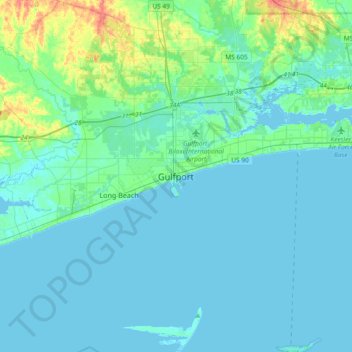
Name: Gulfport topographic map, elevation, terrain.

Location: Gulfport, Harrison County, Mississippi, 39502, United States (30.20742 -89.25282 30.52742 -88.93282)

Average elevation: 23 ft

Minimum elevation: -16 ft

Maximum elevation: 171 ft

Harrison County trails, hiking, mountain biking, running and outdoor activities

Gear up for your next adventure:

🎒Gear Packing Cubes - Organize your backpack efficiently
🎒Outdoor Daypacks - Lightweight backpacks designed for carrying maps and essential gear
🔥Plasma Lighters - Windproof lighters that work in any weather condition
🔦Powerful Headlamps - Ultra-bright hands-free lighting for night navigation
🎒Trail Energy Bars - High‑calorie bars for hiking energy

As an Amazon Associate, this site earns from qualifying purchases at no extra cost to you.