Geolocate

Parroquia Rafael Urdaneta topographic map

Click on the map to display elevation.

About this map

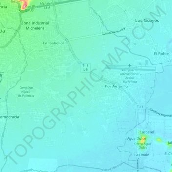
Name: Parroquia Rafael Urdaneta topographic map, elevation, terrain.

Location: Parroquia Rafael Urdaneta, Municipio Valencia, Carabobo State, 1154, Venezuela (10.09565 -67.99731 10.18613 -67.91372)

Average elevation: 1,430 ft

Minimum elevation: 1,375 ft

Maximum elevation: 1,883 ft

Other topographic maps

Click on a map to view its topography, its elevation and its terrain.

Valencia

Venezuela > Carabobo State > Municipio Valencia

The elevation of the city is 520 metres (1,710 feet).

Average elevation: 1,752 ft

Valencia

Venezuela > Carabobo State > Municipio Valencia

The elevation of the city is 520 metres (1,710 feet).

Average elevation: 1,969 ft

Valencia

Venezuela > Carabobo State > Municipio Valencia

The elevation of the city is 520 metres (1,710 feet).

Average elevation: 1,969 ft

Valencia

Venezuela > Carabobo State > Municipio Valencia

The elevation of the city is 520 metres (1,710 feet).

Average elevation: 1,969 ft

Gear up for your next adventure:

🪄Magnetic Compass - Accurate compass for navigation
🧭Pro Hiking Compasses - High-accuracy liquid-filled compasses for topographic orientation
🎒Outdoor Daypacks - Lightweight backpacks designed for carrying maps and essential gear
🕶️Glacier Sunglasses - Side shields to protect eyes from high-altitude snow glare
🛠️Backpacking Tool Kit - Essential toolkit for outdoor repairs

As an Amazon Associate, this site earns from qualifying purchases at no extra cost to you.