Geolocate

Sikeston topographic map

Click on the map to display elevation.

About this map

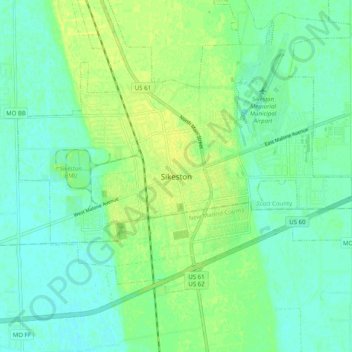
Name: Sikeston topographic map, elevation, terrain.

Location: Sikeston, Scott County, Missouri, 63801, United States (36.83672 -89.62786 36.91672 -89.54786)

Average elevation: 315 ft

Minimum elevation: 292 ft

Maximum elevation: 344 ft

Scott County trails, hiking, mountain biking, running and outdoor activities

Gear up for your next adventure:

🧷Carabiner Set - Durable clips for gear attachment
🧭Outdoor Navigation Book - Learn advanced navigation skills
🛡️Bear Spray Outdoor - Protection in bear country hikes
🧣Hiking Neck Gaiter - Multi‑use neck protection for outdoor weather
👟Men's Trail Runners - Lightweight footwear for fast-paced exploration and light hiking

As an Amazon Associate, this site earns from qualifying purchases at no extra cost to you.