Geolocate

Kangan topographic map

Click on the map to display elevation.

About this map

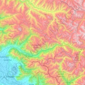
Name: Kangan topographic map, elevation, terrain.

Location: Kangan, Ganderbal District, Jammu and Kashmir, India (34.16056 74.77496 34.46375 75.49617)

Average elevation: 10,942 ft

Minimum elevation: 5,187 ft

Maximum elevation: 17,769 ft

Other topographic maps

Click on a map to view its topography, its elevation and its terrain.

Gagangir

India > Jammu and Kashmir > Kangan

Average elevation: 9,170 ft

Gear up for your next adventure:

🛰️Satellite Messengers - Emergency SOS and two-way messaging for off-grid adventures
⛑️Personal Locator Beacon - Safety beacon for emergencies
📖Nature Tracking Books - Learn to track wildlife and terrain
🧴Hand Sanitizer - Keep hands clean while hiking
🧼Biodegradable Camping Soap - Eco‑friendly soap for outdoor hygiene

As an Amazon Associate, this site earns from qualifying purchases at no extra cost to you.