
Thank you for supporting this site ❤️
Make a donation
Make a donation
Gear up for your next adventure:
As an Amazon Associate, this site earns from qualifying purchases at no extra cost to you.
Rogersville topographic map
Click on the map to display elevation.
Thank you for supporting this site ❤️
Make a donation
Make a donation
Gear up for your next adventure:
As an Amazon Associate, this site earns from qualifying purchases at no extra cost to you.
About this map
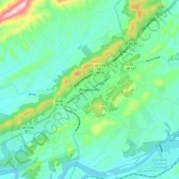
Name: Rogersville topographic map, elevation, terrain.
Location: Rogersville, Hawkins County, Tennessee, 37857, United States (36.36732 -83.04544 36.44732 -82.96544)
Average elevation: 1,306 ft
Minimum elevation: 1,033 ft
Maximum elevation: 2,251 ft
Hawkins County trails, hiking, mountain biking, running and outdoor activities
Thank you for supporting this site ❤️
Make a donation
Make a donation
Gear up for your next adventure:
As an Amazon Associate, this site earns from qualifying purchases at no extra cost to you.