
Make a donation
Gear up for your next adventure:
As an Amazon Associate, this site earns from qualifying purchases at no extra cost to you.
Indian Lake topographic map
Click on the map to display elevation.
Make a donation
Gear up for your next adventure:
As an Amazon Associate, this site earns from qualifying purchases at no extra cost to you.
Indian Lake
Indian Lake has the fourth-highest elevation of towns in Pennsylvania, at 2281 feet. This is the Lake water level, homes at Indian Lake range from 2300 to 2550 feet in base elevation.
Make a donation
Gear up for your next adventure:
As an Amazon Associate, this site earns from qualifying purchases at no extra cost to you.
About this map
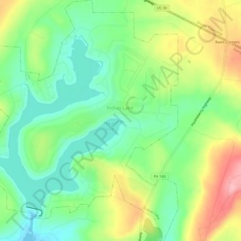
Name: Indian Lake topographic map, elevation, terrain.
Location: Indian Lake, Somerset County, Pennsylvania, United States (40.02331 -78.88721 40.06545 -78.83897)
Average elevation: 2,402 ft
Minimum elevation: 2,228 ft
Maximum elevation: 2,680 ft
Somerset County trails, hiking, mountain biking, running and outdoor activities
Make a donation
Gear up for your next adventure:
As an Amazon Associate, this site earns from qualifying purchases at no extra cost to you.