
Thank you for supporting this site ❤️
Make a donation
Make a donation
Gear up for your next adventure:
As an Amazon Associate, this site earns from qualifying purchases at no extra cost to you.
Shibam topographic map
Click on the map to display elevation.
Thank you for supporting this site ❤️
Make a donation
Make a donation
Gear up for your next adventure:
As an Amazon Associate, this site earns from qualifying purchases at no extra cost to you.
About this map
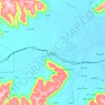
Name: Shibam topographic map, elevation, terrain.
Location: Shibam, Shibam District, Hadramaut Governorate, Yemen (15.88670 48.58625 15.96670 48.66625)
Average elevation: 2,359 ft
Minimum elevation: 2,142 ft
Maximum elevation: 3,284 ft
Thank you for supporting this site ❤️
Make a donation
Make a donation
Gear up for your next adventure:
As an Amazon Associate, this site earns from qualifying purchases at no extra cost to you.