Geolocate

Golden topographic map

Click on the map to display elevation.

About this map

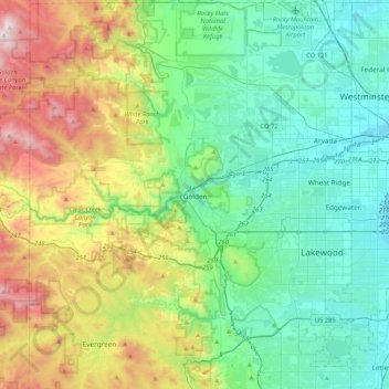
Name: Golden topographic map, elevation, terrain.

Location: Golden, Jefferson County, Colorado, 80401, United States (39.59554 -105.38110 39.91554 -105.06110)

Average elevation: 6,640 ft

Minimum elevation: 5,184 ft

Maximum elevation: 10,466 ft

Jefferson County trails, hiking, mountain biking, running and outdoor activities

Other topographic maps

Click on a map to view its topography, its elevation and its terrain.

Golden

United States > Colorado > Jefferson County > Golden > Golden

Average elevation: 6,352 ft

Gear up for your next adventure:

🔥Fast-Boil Camping Stoves - Efficient cooking systems for quick trail meals
🧼Biodegradable Camping Soap - Eco‑friendly soap for outdoor hygiene
🎁Geography Themed Gifts - Unique gift ideas for map lovers and geography enthusiasts
🩳Quick‑Dry Hiking Shorts - Comfortable and quick‑dry shorts for summer hiking
🪶Wildlife Field Guides - Learn animal tracking and species ID

As an Amazon Associate, this site earns from qualifying purchases at no extra cost to you.