Geolocate

Golden topographic map

Click on the map to display elevation.

About this map

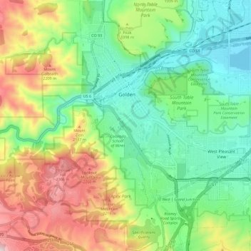
Name: Golden topographic map, elevation, terrain.

Location: Golden, Jefferson County, Colorado, United States (39.70061 -105.24196 39.78711 -105.16186)

Average elevation: 6,352 ft

Minimum elevation: 5,489 ft

Maximum elevation: 7,923 ft

Jefferson County trails, hiking, mountain biking, running and outdoor activities

Other topographic maps

Click on a map to view its topography, its elevation and its terrain.

Golden

United States > Colorado > Jefferson County > Golden > Golden

Average elevation: 6,640 ft

Gear up for your next adventure:

🔦LED Headlamp - Bright and durable LED headlamp for night navigation
🗻Climbing Gear Basics - Essential gear for beginner climbers
🔭Stargazing Telescopes - Perfect for camping in low-light pollution areas shown on maps
🎒Waterproof Dry Bags - Keep your electronics and maps dry inside your pack
🌡️Portable Weather Meter - Track weather conditions on the trail

As an Amazon Associate, this site earns from qualifying purchases at no extra cost to you.