
Tiverton topographic map
Click on the map to display elevation.
About this map
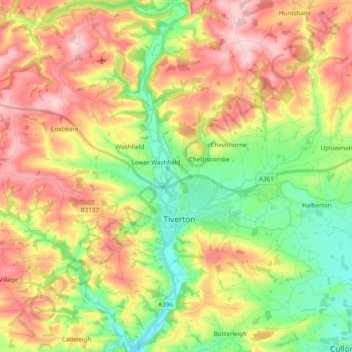
Name: Tiverton topographic map, elevation, terrain.
Location: Tiverton, Devon, England, United Kingdom (50.85668 -3.58845 50.97798 -3.42387)
Average elevation: 515 ft
Minimum elevation: 148 ft
Maximum elevation: 945 ft
Other topographic maps
Click on a map to view its topography, its elevation and its terrain.
White Cross
United Kingdom > England > Devon > Mid Devon > Cheriton Fitzpaine
Average elevation: 430 ft
Bailey
United Kingdom > England > Devon > Mid Devon > Newton St. Cyres > Bailey
Average elevation: 299 ft
St John's Chapel
United Kingdom > England > Devon > North Devon > Eastacombe
Average elevation: 256 ft