
Make a donation
Gear up for your next adventure:
As an Amazon Associate, this site earns from qualifying purchases at no extra cost to you.
Godesberger Bach topographic map
Click on the map to display elevation.
Make a donation
Gear up for your next adventure:
As an Amazon Associate, this site earns from qualifying purchases at no extra cost to you.
Godesberger Bach
Der Bach entspringt als Arzdorfer Bach in Fritzdorf, einem Ortsteil von Wachtberg, auf einer Höhe von 220 m ü. NHN. Zunächst nach Norden abfließend, erreicht der Bach nach etwa einem Kilometer Flussstrecke die Ortschaft Arzdorf, die für den Oberlauf namengebend ist. Weiter in nördliche Richtungen durch das Drachenfelser Ländchen fließend, passiert der Bach Klein Villip und den Grimmersdorfer Hof. Hier wendet sich der Lauf in nordöstliche Richtungen. Unterhalb der Mündung des großen Baches bei der Burg Gudenau ist der Bach als Godesberger Bach verzeichnet.
Make a donation
Gear up for your next adventure:
As an Amazon Associate, this site earns from qualifying purchases at no extra cost to you.
About this map
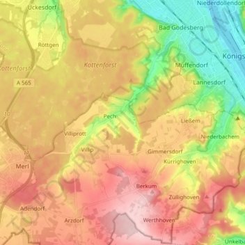
Name: Godesberger Bach topographic map, elevation, terrain.
Average elevation: 554 ft
Minimum elevation: 171 ft
Maximum elevation: 899 ft
Make a donation
Gear up for your next adventure:
As an Amazon Associate, this site earns from qualifying purchases at no extra cost to you.