
Thank you for supporting this site ❤️
Make a donation
Make a donation
Gear up for your next adventure:
As an Amazon Associate, this site earns from qualifying purchases at no extra cost to you.
Szokolya topographic map
Click on the map to display elevation.
Thank you for supporting this site ❤️
Make a donation
Make a donation
Gear up for your next adventure:
As an Amazon Associate, this site earns from qualifying purchases at no extra cost to you.
About this map
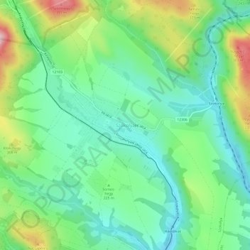
Name: Szokolya topographic map, elevation, terrain.
Location: Szokolya, Szobi járás, Pest, Central Hungary, 2624, Hungary (47.84679 18.98893 47.88679 19.02893)
Average elevation: 751 ft
Minimum elevation: 479 ft
Maximum elevation: 1,355 ft
Thank you for supporting this site ❤️
Make a donation
Make a donation
Gear up for your next adventure:
As an Amazon Associate, this site earns from qualifying purchases at no extra cost to you.