
Thank you for supporting this site ❤️
Make a donation
Make a donation
Gear up for your next adventure:
As an Amazon Associate, this site earns from qualifying purchases at no extra cost to you.
Minzhi Sub-district topographic map
Click on the map to display elevation.
Thank you for supporting this site ❤️
Make a donation
Make a donation
Gear up for your next adventure:
As an Amazon Associate, this site earns from qualifying purchases at no extra cost to you.
About this map
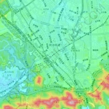
Name: Minzhi Sub-district topographic map, elevation, terrain.
Location: Minzhi Sub-district, Shenzhen, Guangdong Province, China (22.58399 113.98795 22.64830 114.06654)
Average elevation: 328 ft
Minimum elevation: 72 ft
Maximum elevation: 1,188 ft
Thank you for supporting this site ❤️
Make a donation
Make a donation
Gear up for your next adventure:
As an Amazon Associate, this site earns from qualifying purchases at no extra cost to you.
Other topographic maps
Click on a map to view its topography, its elevation and its terrain.