
Darjeeling topographic map
Click on the map to display elevation.
About this map
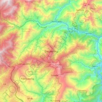
Name: Darjeeling topographic map, elevation, terrain.
Average elevation: 4,344 ft
Minimum elevation: 531 ft
Maximum elevation: 10,056 ft
Other topographic maps
Click on a map to view its topography, its elevation and its terrain.
Singalila National Park
India > West Bengal > Darjeeling Pulbazar > Gorkhey
Average elevation: 8,192 ft