
Make a donation
Gear up for your next adventure:
As an Amazon Associate, this site earns from qualifying purchases at no extra cost to you.
Le Rossin topographic map
Click on the map to display elevation.
Make a donation
Gear up for your next adventure:
As an Amazon Associate, this site earns from qualifying purchases at no extra cost to you.
About this map
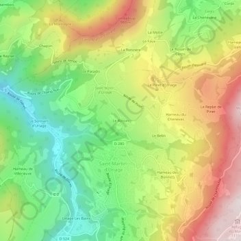
Name: Le Rossin topographic map, elevation, terrain.
Average elevation: 2,280 ft
Minimum elevation: 1,089 ft
Maximum elevation: 3,757 ft
Make a donation
Gear up for your next adventure:
As an Amazon Associate, this site earns from qualifying purchases at no extra cost to you.
Other topographic maps
Click on a map to view its topography, its elevation and its terrain.
Saint-Nizier-d'Uriage
France > Auvergne-Rhône-Alpes > Isère > Saint-Martin-d'Uriage
Average elevation: 2,195 ft
Les Seiglières
France > Auvergne-Rhône-Alpes > Isère > Saint-Martin-d'Uriage
Average elevation: 3,327 ft
Villeneuve d'Uriage
France > Auvergne-Rhône-Alpes > Isère > Saint-Martin-d'Uriage
Average elevation: 1,886 ft
Make a donation
Gear up for your next adventure:
As an Amazon Associate, this site earns from qualifying purchases at no extra cost to you.