
Waynesboro topographic map
Click on the map to display elevation.
Waynesboro
According to the United States Census Bureau, Waynesboro has a total area of 5.5 square miles (14.2 km2), of which 5.4 square miles (14.0 km2) is land and 0.039 square miles (0.1 km2), or 0.96%, is water. The city's elevation is 295 feet (90 m) above sea level. Pine, oak, dogwood, and other trees found in the South are in Waynesboro.
About this map
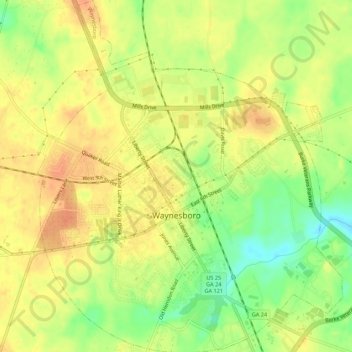
Name: Waynesboro topographic map, elevation, terrain.
Location: Waynesboro, Burke County, Georgia, United States (33.07199 -82.03730 33.11779 -81.98984)
Average elevation: 285 ft
Minimum elevation: 197 ft
Maximum elevation: 341 ft
Burke County trails, hiking, mountain biking, running and outdoor activities