Geolocate

Buli topographic map

Click on the map to display elevation.

About this map

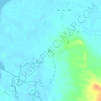
Name: Buli topographic map, elevation, terrain.

Location: Buli, Quezon, Calabarzon, Philippines (14.13250 122.18976 14.17250 122.22976)

Average elevation: 20 ft

Minimum elevation: -3 ft

Maximum elevation: 128 ft

Gear up for your next adventure:

💧Water Filtration Bottles - Safely drink from streams and lakes while exploring
📶Satellite Messenger - Communication device off‑grid
🧭GPS Watch Accessories - Bands and chargers for GPS watches
🚑Emergency Bivvies - Heat-reflective sleeping bags for survival situations
☀️Outdoor Sunscreen - High protection sunscreen for outdoor activities

As an Amazon Associate, this site earns from qualifying purchases at no extra cost to you.