Geolocate

Tangcal topographic map

Click on the map to display elevation.

About this map

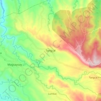
Name: Tangcal topographic map, elevation, terrain.

Location: Tangcal, Lanao del Norte, Northern Mindanao, 9221, Philippines (8.00591 123.90181 8.08591 123.98181)

Average elevation: 1,037 ft

Minimum elevation: 144 ft

Maximum elevation: 2,185 ft

Other topographic maps

Click on a map to view its topography, its elevation and its terrain.

Linamon

Philippines > Lanao del Norte

Average elevation: 138 ft

Kolambugan

Philippines > Lanao del Norte

Average elevation: 180 ft

Gear up for your next adventure:

Camping Coffee Makers - Enjoy premium coffee at the summit or campsite
👓Polarized Sunglasses - Outdoor sunglasses for glare reduction
🧣Hiking Neck Gaiter - Multi‑use neck protection for outdoor weather
🪶Camping Sleeping Pad - Comfortable sleeping pad for backpacking
🪶Survival Guide Book - Expert advice for emergency preparedness

As an Amazon Associate, this site earns from qualifying purchases at no extra cost to you.